

Ever since scientists discovered the water in Blue Lake is the clearest in the world in 2011, the secret has been slowly getting out about this magical place in the South Island of New Zealand. The lake is deep inside the Nelson Lakes national park, about 45 minutes south of the town of Nelson. To access it you need to hike about 120 km, taking between 5-7 days to “tramp” (as our kiwi friends like to say) on the Travers Sabine circuit through the national park, starting from the town of St Arnaud. It is a long journey into some of the best wilderness that New Zealand has to offer.
Walking into the wild for that long these days is increasingly difficult in the tech driven world we live in. I was looking forward to getting back to basics, on a long and physical journey, my longest hike to date. The track is not too busy like some of the Great Walks, and has the right amount of people in the huts along the way.
I was a little nervous as I set out from the town of St Arnaud, walking up the Travers Valley alongside Lake Rotoiti. The reason was that the Department of Conservation had just issued an alert for all the huts in the circuit, saying there was a disease risk. There was a norovirus running amok in the valleys, particularly the Sabine valley, known to cause extremely severe diarrhea and vomiting, and was transmitted through the huts where everyone stayed the night. It lasted only a day or two, but it was contagious for two days after symptoms stopped and it had an incubation period of two days. It did not sound fun at all.

It was also raining. Not just showering, but actual big drops that soak into everything. There is not a reasonably priced jacket out there that can handle that type of rain. I was slowly getting really wet. My backpack was too heavy as well, too heavy for a long journey like this. I’d been food shopping in Nelson the night before, and had hastily grabbed things I thought were needed for a circuit that could take up to a week to complete.
I followed the banks of Lake Rotoiti for the first 10km, crossing the odd stream but generally very flat and easy walking. I caught up to some French girls along the way, Cecille and Suzanne. We had lunch at Lakehead hut but it was too early to stop for the day, so I hiked on to John Tait hut, another 15km up the valley. I made it late in the afternoon, having achieved a long and tough 25km first day. The girls came in a little later. The valley was getting very green and beautiful already, and the rivers and streams very blue. The mountains were not visible, but a few breaks in the cloud told me they were getting big.
I met some great people this first night- Ben and Julie from Colorado, a Kiwi girl, an Israeli couple and of course Suzanne and Cecile from France. I was crossing Travers Saddle, and at 1710m above sea level, it was clear it would be an uphill slog from here. I decided to ditch some of my overstocked food. My pack was still heavy though as I set out the next day, with the track starting to get thinner. I passed the pristine Travers Falls, and stopped to admire its perfection. I continued on up the tree covered slope for a couple more hours until I finally came to Upper Travers hut, sitting on the edge of the beech forest and the rocky alpine section above. I was the first to arrive, as it was only about midday. I hoped to press on and cross Travers Saddle that day given how much light was left.
A few things made me reconsider this. Firstly, the weather was turning grim again. The wind was picking up, and the temperature dropping. To confirm my suspicions that I should not attempt the pass that afternoon, I came across a Missing Person poster in the hut. It told the story of a 19 year old German backpacker who had recently disappeared on the saddle. They found his backpack on the side of the track, but not him. An extensive search and rescue was conducted but no trace was ever found. He was described as a cautious and happy hiker. So I decided the better option was to relax, and went for a swim in a nearby stream to freshen up.
Then more people starting showing up. Ben and Julie from Colorado again, the Israelis, as well as many who were coming in the other direction. The first were the young Kiwi guys Scott and his daredevil mate, who had just scaled Mount Franklin, one of the biggest peaks in the national park. They described the many times the previous day when they were clinging to rock with their fingers, holding onto cliff faces with no support below, certain death. To me, it sounded terrifying; to these boys, it was all a good afternoon’s fun.
Scott was also vivid in his description of the impending doom we faced in the Sabine valley over the other side of the saddle. The norovirus was running rampant there, and people were dropping like flies. He had caught a milder version of it and had largely recovered, but was likely still in the contagious phase.
I knew I would encounter the virus, but hoped my immune system could overcome it. It didn’t help that I was not sleeping too well in these mountain huts though, where snoring is usually a feature of the night with so many people jammed in together like sardines. I had packed ear plugs, but the decibels were too high for that.
Older Scott also showed up. He had literally just finished the Te Araroa trail running the whole length of New Zealand, some 3000km long. He had to come back to this area to finish though, as he had been snowed in on his first time through this section, spending three days stuck in the hut before retreating and deciding to come back later when the snow had melted.
It actually started to snow outside here now. Big wet flakes were accumulating on the front porch, and the surrounding mountain faces were getting a white look to them. The wood was stacked higher in the stove, and socks, shoes and towels hung all around, drying out from the wet.

More and more people kept showing up, people from all over the world. The visitors log book showed how international the crowd was. Almost every country was represented. It’s good to know there are still places like this where people can interact without the distractions of our phones.
Games of chess and cards were being played all around. I was in a conversation with both Scotts about how to cut down the weight in your backpack. Getting the gear and food situation right for a long multi-day hike had been tough. To get it too far wrong in either direction on such a long trip can be either fatal in terms of not having enough gear such as a tent or warm clothes if you get stuck somewhere away from the huts, or overly heavy leading to unnecessary pain and misery along the way.
The hut filled up to be full - around 25 people. The snoring was intense again. It was probably the same Israeli guy from the night before. The next morning, snow was everywhere. It had accumulated overnight to be quite a significant fall for mid-summer.
The ascent straight out of the hut was steep and relentless, developing into boulder hopping at the top. The saddle was crossed and the big descent into the Sabine Valley began. The weather today was perfect - very lucky to have it on the saddle crossing day. The view across the valley to the distant valleys and peaks was amazing. I shook my head in awe and respect as I looked across at Mount Franklin where Scott and his buddy had climbed the day before.
I moved down through rock scree, suddenly very steep. Continuously jumping down from big rocks with a heavy backpack is not easy. I moved into the dark green canopy of the beech forest, orange markers pointing the way all the time. Following them becomes very important as the track becomes thinner and thinner, many times not even visible at all.
The track was incredibly muddy, and the steepness of the terrain meant frequent slides in the mud were a feature of this section. Only by grabbing onto the surrounding trees and plants was I able to arrest some of my slides. My pants and pack were now covered in mud. Nice.
I arrived at West Sabine hut, ground zero for the norovirus given its central location, being where the turnoff to Blue Lake hut begins. People passed by going in all directions. It was only around noon when I arrived at the hut, and I ate some quick snacks on the hut deck with a bunch of young Australian guys, as well as Ben and Julie from Colorado. I knew them from the past two nights in huts, and they were great company, being on a round-the-world trip and doing some awesome hikes along the way. They were strong hikers too, and we hit a good pace on the final climb up to Blue Lake. The climb was very steep towards the end, and being a small track it was basically pulling yourself up and over big rocks with your hands.

We had passed a section with massive truck-sized boulders all over the place, very shiny and new rocks mixed in with the other rocks which all had a thick green layer of moss. It was clear the boulders were shiny and new, and the passing DOC worker confirmed what I suspected- it was from the Kaikoura earthquake a couple of months ago. The size of these things was mind-blowing, and there were so many it was lucky that it had happened in the middle of the night so no hikers were passing through at the time. What was even more amazing was the fact that they had pretty clearly come from a giant scree slope on the other side of the river we were following. They had apparently bounced across the river, a pretty amazing thing to consider. Giant trees lay strewn everywhere, snapped like twigs from the tumbling boulders.
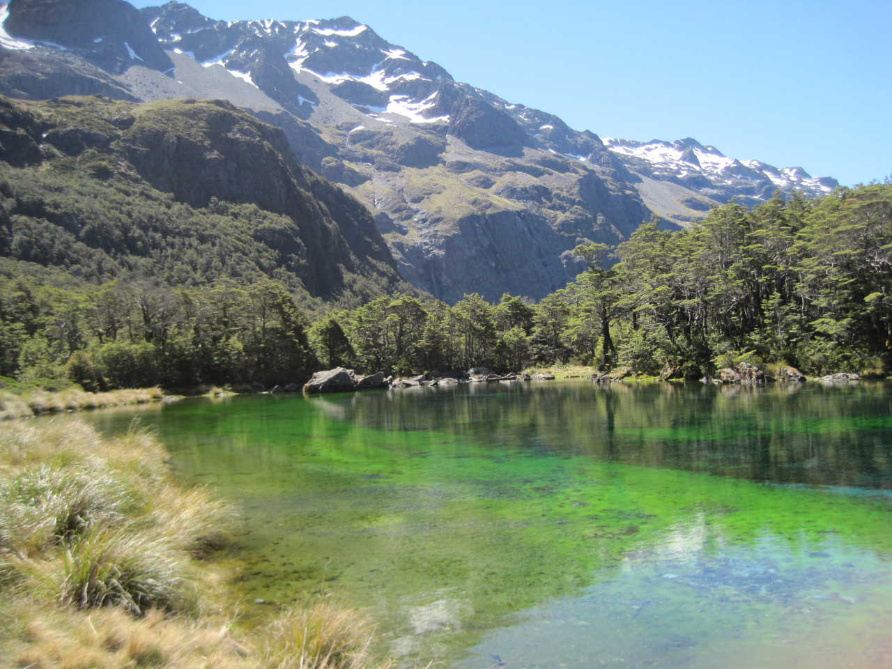
We finally hit Blue Lake exhausted, but energetic enough to strip off and jump (very briefly!) into the icy cold Blue Lake. It was definitely as beautiful as I had hoped, and the setting was even more spectacular, ringed by huge mountains all around. The colours included all shades of blue, mixed in with green. The water was a chilly 5 degrees Celsius, just above freezing temperature. A sign told us that fact, and also told us how it came to be the clearest water in the world, around 80 metres.
There was still plenty of daylight left given how late the sun sets down in these latitudes, so I spent the rest of the day taking photos and walking around the lake. I decided not to stay in the hut that night given I had just carried a tent this far and the extra 2.7 kilos I had carried needed justification after all. So I set up shop in prime position with beautiful peaks above and the stunning blue water below. A great day. I was pretty stoked with this hike!
That night the earth gave a very noticeable shake. The next day I heard from Ben that he had felt it too. These mountains were on the move. I would later hear from a local that this was the Maori spirits telling me I shouldn’t have dived in their sacred lake earlier that day. As unlikely as that is, I hadn’t thought about the issues brought about by the fact that more people are coming here now that it got the “clearest water in the world” title, and what effect that will have on the fragile environment.
The next day was the biggest of all, going back to West Sabine Hut and back down the Sabine Valley towards St Arnaud where the hike began. While comparatively flat compared to other sections, it was long and relentless, moving up and down small rocky embankments on a long river. The track was very primitive, but it was always nice to look down at the blue river below.
The mountains slowly got smaller as I approached Lake Rotoroa, the other giant lake in the national park. The weather looked ominous once again. It was around 23km that day, on a barely visible and rocky track. Not easy going at all. My legs were seizing up, particularly my right quadricep. I limped into the hut and lay down my pack before jumping in the cold lake to wash up.

The sandflies were particularly bad here, probably from being near the lake. But after covering all exposed surfaces we sat around talking. That night there was an Englishman, a Russian couple, a German couple from a few nights back, and then Ben and Julie had come in from Blue Lake too. The Englishman had been tramping solo into even more remote corners of the national park, and his tales of getting lost and bushwhacking huge sections didn’t sound too fun.
We collapsed into bed later on, and the following day was the last hike out to the carpark. It would be a moderate day, around 20km but over slightly easier terrain than the previous day. After stopping for lunch at Speargrass hut and meeting a bunch of locals doing a day hike and eating lunch there, I continued onwards before everyone else, seeing the skies getting darker. It proved to be a good decision, as the rain set in again, just as it had been like when I started the hike five days ago. What had come in between had been spectacular though. It would take me a week to recover, but the great thing is that the pain begins to be forgotten with time, and all that is left are the good memories of meeting cool people in beautiful, untouched nature. And no sign of any norovirus.
What more could one want, right? Actually, a warm shower, soft bed and clean clothes would be nice at this point!
Words: Stephen Sexton
For more writing by Stephen, click here